Monday, July 27, 2009

Chicago Community Area #42 - Woodlawn

Yesterday was a beautiful mostly-sunny day and a great day for a ride on the Lakefront Trail. At the south end of the trail, I passed along the edge of Jackson Park, in the Woodlawn neighborhood. Riders who stick to the trail and drivers who pass by on Lake Shore Drive come amazingly close to one of the most spectacular of all public art works in Chicago.

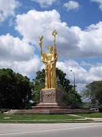
Tucked behind a bend in the road and not visible from the main thoroughfaire, it's the beautiful statue of The Republic on Hayes Drive. The 24-foot statue is a replica of the original statue which was created for the Worlds Fair in 1893. The original was almost three times as large and stood 65 feet tall!

Monday, July 20, 2009

Chicago Community Area #26 - West Garfield Park

I headed out to West Garfield Park yesterday. It's one of the smaller community areas on the far west side of the city. On a warm summer day around noon, the Madison St commercial district, between Hamlin and Pulaski, was bustling. Not particularly inviting, but it was bustling with people. This intersection of Madison and Pulaski was the site of urban riots in the 1960s, particularly in 1968, and although there are many shops on this strip today, it has never fully recovered.

According to the Encyclopedia of Chicago, this commercial district started developing after 1914. At that time, Pulaski Ave was known as Crawford Street. In 1933, Mayor Ed Kelly tried to have Crawford renamed after Casimir Pulaski, a Polish-born American Revolutionary War Hero, in order to gain favor with Chicago's large Polish community. Business owners in the area protested the name change. The protests continued, lawsuits were filed, and injunctions were issued until the Illinois Supreme Court finally ruled in favor of the name change in 1952. As you can see from the photo, some owners still refuse to change their signage.

Chicago Community Area #2 - West Ridge

Although West Ridge is my home 'hood, I haven't taken the opportunity to officially document it until this week. There's nothing more iconic in West Ridge, known as West Rogers Park to natives, as Thillens baseball field at Kedzie and Devon. Thillens and its major league sized baseball signage have been around since I was a kid. When my parents would drive by Thillens with us in the car, the kids would dream of playing in the "big leagues" at a game at Thillens.

I don't think I ever got the chance to play there, but my kids have played at Thillens. Thillens opens the park for charity organizations who collect the gate fees for the organization. I don't know if Thillens themselves takes a cut at all. I don't think so. Yesterday, the Oriole Park Baseball League was charity of the day. Kids and parents were all very excited to play on a "real" baseball diamond with a real scoreboard and have the kids' names announced on the loudspeaker when they came up to bat. It doesn't get better than that!

Monday, July 13, 2009

Chicago Community Area #55 - Hegewisch

Hegewisch (pronounced "heg-wish") is the furthest southeast neighborhood in Chicago. The Burnham bike trail runs through the northern section of Hegewisch which also includes Eggers Grove forest preserve and the William Powers State Fish and Wildlife Area.

Powers SFWA is on the peaceful Wolf Lake. On the day I rode there, there were lots of families enjoying the nice weather and picnicing in the park. There was once a Nike missile battery in this park and there is now a monument to that installation in the park. The "missile" on this monument is actually just the warhead (neutralized) of the missile. The actual booster rocket of the missile was much larger.

Warning to all bikers! Do NOT ride on Ave O! It is full of potholes and just before I got to Powers SFWA, I got not one, but two flat tires! I didn't even realize that I had blown both tubes until I had finished changing my back tube and got back on to ride. To get into Powers SFWA, take the turn-off on the left side of Burnham Trail as you go south from Eggers Grove, about 200 yards before you get to Ave O.

Chicago Community Area #52 - East Side

I didn't see much of the neighborhood as I passed through the East Side community area. They have a nice bike path along Indianapolis Blvd under the east end of the skyway.

The community is very residential and has a very suburban feel to it.

State Line Rd runs along the Illinois-Indiana border. The streets to the west (the Illinois side) are named Ave B, Ave C, Ave D, etc. Before I came to down here the first time a few years ago, I didn't know that Chicago had letter-named streets. I thought that was something unique to New York.

Chicago Community Area #46 - South Chicago

After detouring from my usual route south of the South Shore Cultural Center to visit several former synagogues in the South Shore area, I ended up riding diagonally south-east on South Chicago Ave, along the edge of the South Chicago neighborhood. At the 3-way intersection of South Chicago, 92nd and Exchange, there's a little triangle formed by the intersecting streets. A small monument to Christopher Columbus stands on that triangle. It looked like something I would expect to see in Grant Park or Lincoln Park, not on a relatively forsaken strip in South Chicago. As it turns out, according to a Museology web site, this monument was originally in the downtown area, but was moved to its current location in 1909.

The fountain was a donation of John B Drake in 1892, apparently to commemorate the 400 year anniversary of Columbus coming to America. The artist was R. H Frank and it is fashioned in the Victorian Gothic style. According to this web site, the foundation has a recepticle holding two tons of ice and has ten faucets, each provided with a bronze drinking cup.

I rode east on 92nd and crossed the Calumet River there. As I approached the bridge, it was just closing after letting through a huge barge.

Chicago Community Area #43 - South Shore

On yesterday's long ride, I went all the way south along the lakefront path and further to the Indiana state line. My first stop was at the South Shore Cultural Center. This building was originally built in 1916 in the Mediterranean Revival style as an exclusive country club. The club had a well-known policy of excluding Jews, Catholics and African-Americans.

In the 1970s, the club closed and the building was sold to the Chicago Park District and was renovated. It's really beautiful, both inside and outside. Now, of course, the center is open to people of all races, religions and nationalities. The wedding reception for Barack and Michelle Obama was held here in 1992.

Wednesday, July 8, 2009

Chicago Community Area #21 - Avondale

Avondale is a small neighborhood south of Irving Park and north of Logan Square. I went on an architectural tour of Avondale last year, sponsored by Big Shoulders Realty. The area is primarily residential and there aren't a lot of famous sites to see, but Avondale does have some beautiful old buildings dating back to the 1890s.


In addition, I also found a unique Guatemalan bakery on Diversey. The lady who works there is very nice and there's a small area to have a drink or something from the bakery.


Tuesday, July 7, 2009

Chicago Community Area #19 - Belmont Cragin

I continued riding west on Armitage until it turned into Grand. At Grand and Long, I could see Prosser Career Academy. The high school has a beautiful, columned entrance, but unfortunately, an addition has been built on to the building that blocks the former entrance. I don't know if students can enter through the original doors, but I couldn't find a way to get close enough to photograph it. Instead, I went further west to Central Ave and south up the bridge over the railroad tracks. From there, I could almost get a photo of the original face of the building.

The field around the school is huge and includes several baseball diamonds, playgrounds and Hanson Stadium. The Chicago Police Grand Central district headquarters is at the corner of Grand and Central where I took this photo.

At the far west side of Belmont Cragin, where Grand meets Fullerton, the Radio Flyer Company has a giant red wagon in front of the their building.

Chicago Community Area #20 - Hermosa

Yesterday's ride took me west of Logan Square along Armitage Ave through Hermosa. I turned south at Keeler to visit the Factor 10 House.


The Factor 10 House was designed to reduce life-cycle environmental impacts by a factor of 10 compared to the average home built in America today.

There's no central air conditioning. It was designed to be cooled by natural cross ventilation throughout the open floorplan. Window placement maximizes reflected light within the interior with is painted white. The building has a green roof.

You can read more about the Factor 10 House at:

Monday, July 6, 2009

Chicago Community Area #64 - Clearing

After passing through Garfield Ridge, I continued south on Narragansett into Clearing, the neighborhood with borders Midway Airport on the south and southwest sides. Turning back east on 63rd, I found the Midway fire department. In front of the fire house, there is a decorative portal and an interpretive panel explaining it. Some snippets from the panel:

This portal displays two relief sculpture and a limestone lintel. Both architectural artifacts were salvaged from Chicago firehouses that have been demolished. The terra-cotta reliefs on the columns were originally installed on the facade of a fire house located at 2740 N Sheffield Avenue. The limestone lintel, inscribed "Chicago Fire Department," was saved from the main doorway of Engine Company #103, located at West Taylor and Laflin Streets.

The reliefs on the columns depict fire fighting tools hand carved in the hard, brown-red earthenware called terra cotta. In the panels, hoses and ladders, interwoven in a fluid composition suggestive of vines growing on a trellis, are placed against a background of laurel leaves, symbolic of honor. Overlaid on this are fire helmets and axes which integrate a heraldic crest into the organic composition.

The terra cotta panels originally framed the second story windows of the Lakeview Village Hall, which was constructed in 1886 by the City of Lakeview, before Lakeview voted to join the City of Chicago in June 1889.

I asked permission and was allowed to look around the firehouse and its unique equipment. They even have on piece which has a huge poker on the front of it which the firemen explained to me could be used to puncture a fuselage, if necessary.

Chicago Community Area #56 - Garfield Ridge

Continuing southwest on Archer, it straighten out a bit at Pulaski and started heading straighter west. After passing Cicero, I entered the Garfield Ridge neighborhood. Garfield Ridge surrounds Midway Airport on the north and northwest sides. Planes pass overhead frequently, especially those from Southwest Airlines which runs major operations out of Midway.

Archer continues its southwest path until 55th street, where the two streets merge and continue straight west as 55th. This is also the junction with Narragansett, which runs north-south. I turned south on Narragansett and stopped at Wentworth Park, which is named for John Wentworth, a 6-term US representative in the 1840s and 50s and a two-term mayor of Chicago in the late 1850s and early 1860s. As mayor, Wentworth tried to clean up the local red-light district, known as the Sands. According to the book, To Serve and Collect, the mayor created a ruse by arranging a horse race and cock fight in another part of the city. This distracted many of the Sands' customers and while they were preoccupied with the other vices, the mayor led the deputy sheriff and 30 policemen in clearing out the remaining tenants and tearing down 5 buildings and several shanties. Sounds familiar. :)

Adjacent to Wentworth Park are Kennedy High School and Kinzie Elementary School. Kinzie has several nice mosaics on its walls, welcoming the kids to the school. John Kinzie was the first permanent white settler in Chicago.

Chicago Community Area #57 - Archer Heights

Continuing southwest on Archer Avenue, I came to the Archer Heights neighborhood. This neighborhood has a strong Polish identity, particularly the Polish highlands. The highlands is an area in southern Poland, where the Carpathian Mountain range forms a natural border with Slovakia. The highest peaks in this range are the Tatra Mountains. The highlands is one of the most popular tourist areas in Poland.

Along Archer Avenue, at 4808 S, is the Polish Highlanders Alliance in America building - a social club which is the national headquarters for Polish highlander clubs across the US. The building's architecture is distinctive and described as a Carpathian chalet in the traditional Zakopane style.

The Szałas restaurant is similar in style to the PHAA building, but significantly taller. It really looks like a highlands chalet. Although I haven't been inside, online review sites describe how this restaurant is elaborately decorated with decor from the Polish highlands. On the outside, I found it particularly amusing that you can't just walk in the front door. Rather, you pull on a rope next to the door and a few minutes later one of the staff, dressed in highlander traditional garb, answers the door and lets you in. I saw this happen to a group of people when I was there, but I didn't understand why they needed to wait. It was only after I read about this unusual protocol in online reviews that I figured out what was happening.

Outside Szałas, there's a garbage can inside a box made of small logs that matches the restaurant's theme.

Chicago Community Area #58 - Brighton Park

Although my general plan was to roll straight southwest on Archer, I took a detour in Brighton Park to find an former synagogue in the area that is now a church. This area never had a large Jewish population. In fact, I don't know of a single synagogue in this entire southwest side area today. But apparently at some point there was enough of a population to support a synagogue at the corner of 38th and Homan. You can clearly see where the Star of David was cemented in over the doorway.

After returning to Archer Ave, I found another former place of worship. This time it was the former Our Lady of Fatima church, a very impressive building with some cool stone carvings around the doorway. The new building is a few blocks away at 2751 W 38th Pl.


I also spotted a vintage bulb sign at Balzeka's Used Cars. Click on the photo to enlarge and you'll see the message "u will like us" on the side of the sign. The use of the contracted "u" seems ahead of its time for a sign from this period.

Chicago Community Area #59 - McKinley Park

After cruising through South Lawndale past the Cook County Courts at 26th and California and the Correction Centers just south of there, I glided east on 31st and continued south on Western until it hit Archer Ave in McKinley Park.

McKinley Park - the park itself - is a 69 acre park that includes a swimming pool in the field house. One of the interesting things that I've seen at the field house both times I've visited is the badminton club that meets there. These guys and gals play a very serious and fast game of badminton.

The park is named for President William McKinley who was assassinated in 1901. The park was created a year later. According to the Chicago Park District web site, this park was unique in that it was created within the city itself, not at its edges. The success of the park led to other large inner city parks in Chicago and around the country. A statue of McKinley stands in the northwest corner of the park.

There's a cool review of the entire McKinley Park neighborhood on Yelp. According to entry #7, the factory that made Ron Popeil's Veg-o-matic is at 2323 W. Pershing and is now the McKinley Park Lofts.

Chicago Community Area #30 - South Lawndale

Riding south on Marshall to the corner of Cermak (22nd), I found the impressive Marshall Square Theater, a former vaudeville venue, which is now a banquet hall under the name "Apollo's 2000". The vertical signage jutting out from the facade makes me crazy (stupid, stupid stupid!), but it's still an impressive building. It was designed by Alexander Levy and built in 1917 and remodeled (with the vertical sign, grrr) in 1936. According to the Cinema Treasures web site, of the 11 theaters which Levy designed in Chicago, this is the only one which is still open.

Equally impressive is the massive former Carter Harrison Technical High School. It was named for a former Chicago mayor who served 5 terms in the 1800s. The high school opened in 1912 and closed (as a high school) in 1983.

Chicago Community Area #29 - North Lawndale

On my Sunday long ride yesterday, I followed the "emerald necklace" down to North Lawndale. My mom grew up in this neighborhood and it was once home to a very large Jewish community. I followed Hamlin south as it turned into Independence Blvd. At 1400 south, there's a fountain at a traffic circle where Independence meets Douglas Blvd. I think the fountain, which portrays children celebrating, was created to commemorate the victory in WWII. However, there's not much information online about this fountain and the plaque not says that it was renamed Harold Washington Fountain Square in the 1980s.

There are many former synagogues along Douglas Blvd and in the surrounding area. All of the synagogues have either been converted to churches or are boarded up. Touring the area gave me a sense of the grandeur that was part of this neighborhood. You can tell how beautiful they were in their day and you could almost hear the sounds of the throngs of people who would pray and learn there.